Available with Image Server
Straight-line distance can be altered when a barrier is present and when a surface raster is specified. A surface raster incorporates the actual distance encountered adjusting for the ups and downs in the landscape surface. Once the adjusted straight-line distance is identified, the rate that distance is encountered by a traveler can be determined. The adjusted straight-line distance must be accurate to capture the true movement of the traveler.
The basic straight-line distance without a surface raster or barrier applied theoretically models the traveler as if it were flying just above the surface. When the landscape surface is incorporated in the distance calculations, it accounts for the additional distance the traveler will cover because they are moving over the undulations in the landscape. The landscape surface is identified by a surface raster and is typically an elevation surface.
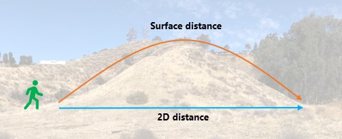
The image below illustrates how the general calculations are performed. Since the route from point A to point B is uphill, the traveler needs to travel farther than if the route were flat. The distance that would be traveled is referred to as the surface distance.

Unless the cell is flat, the surface raster will always increase the distance to move through it.
The rate at which the adjusted distance is encountered can be controlled by a cost surface, the source characteristics, a vertical factor and a horizontal factor. If any of these factors are specified, the distance to move through a cell (adjusted for the surface raster) is multiplied by the cost associated with the cell.
The surface distance is not to be confused with the vertical factor. The surface distance increases the actual distance the traveler will travel. The vertical factor is the effort to overcome the slopes the traveler encounters when moving over the landscape.
Surface raster use examples
A surface raster can be used to help solve various scenarios, such as the following:
- Determine how much water will be required to protect a neighborhood in a mountainous area from an advancing brush fire when you need to spray a 500-meter straight-line protection buffer around the houses. It is necessary to determine the actual surface area that needs to be covered.
- Determine the actual distance that must be traveled by rescuers to reach an injured hiker.
- Determine the number of steps you will register on your fitness tracker when you go for a run.
Adjust straight-line distance analysis with a surface raster
Distance analysis can be divided conceptually into the following related functional areas:
- Calculate straight-line distance and, optionally, adjust the calculations with a barrier or surface raster.
- Optionally determine the rate the distance will be encountered using a cost surface, source characteristics, vertical factor, and horizontal factor. Create the accumulative distance raster.
- Connect regions over the resulting accumulative distance surface using an optimal network, specific paths, or a corridor.
From the first functional area, the straight-line distance is adjusted with a surface raster as illustrated below. The scenario involves a collection of four forest ranger stations (purple dots), and some rivers (blue lines).
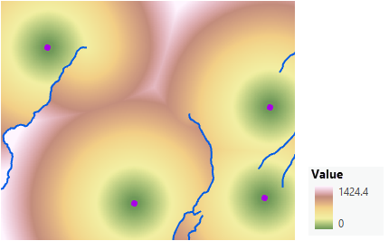
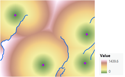
When also adjusting the straight-line distance for the surface distance, there are only slight spatial changes in the overall raster, but the range of the values does change.
Create an accumulative distance raster that adjusts for the surface
To create an accumulative distance map that incorporates the actual surface distance, complete the following steps:
- Open the Distance Accumulation tool.
- Provide the source in the Input raster or feature source data parameter.
- Name the output distance raster.
- Identify the surface raster in the Input surface raster parameter.
- Specify any other necessary parameters.
- Click Run.
Surface raster affects distance calculation
The input surface raster is used to determine the actual surface distance traveled from one cell to the next. The surface distance is an adjustment to the straight-line distance. Elevation data is often used as the input surface raster.
When locating a new building complex, the closer the building is to existing power lines, the better. In the following image, the distance to the closest power line (blue lines) is identified for each cell. The more green a cell is, the closer it is to a power line. The distance was calculated with a barrier, the ridge line (the purple line), but without specifying a surface raster.
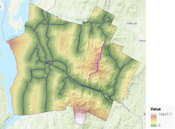
In the following image, that same distance is calculated, but this time with a surface raster input specified. The two maps appear similar but the ranges are different in their legends. The surface distance increases the overall distance that must be traveled.
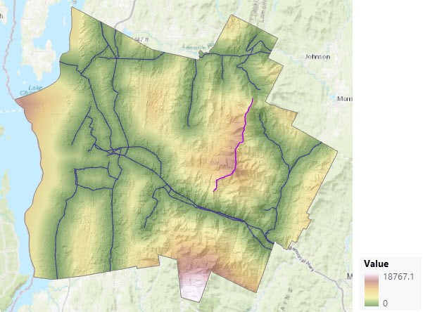
If the landscape is not flat, the accumulative distance is always greater when a surface raster is provided. When one or multiple rate controlling factors—a cost surface, source characteristic, vertical factor, or horizontal factor—are also provided, greater distance means that more cost is incurred at the rate determined by these factors.
The surface raster can affect the output back-direction, source direction and distance allocation rasters when calculating straight-line distance, particularly in rugged terrain. When a cost surface, vertical factor, horizontal factor, and source characteristic input are provided, these three outputs may change depending on the undulations and their steepness in the surface raster and the variation in the cost surface. Steep locations have a greater surface distance, and if the location has high cost, the final output accumulative distance and accompanying values may increase significantly.
Often the same elevation raster that is used for the surface raster is also used as the vertical factor raster.
Additional applications incorporating a surface raster
The following are sample applications in which straight-line distance is adjusted to account for the surface distance to address specific problems.
Identify the shortest surface distance
To calculate the shortest surface distance between two points, use one of the points as the input to Distance Accumulation, along with an elevation surface for the Input surface raster parameter. Use the accumulative distance and back direction outputs, along with the second point, as inputs to the Optimal Path As Line tool. The generated path will be the shortest surface distance back to the first point.
Calculate distances along a network
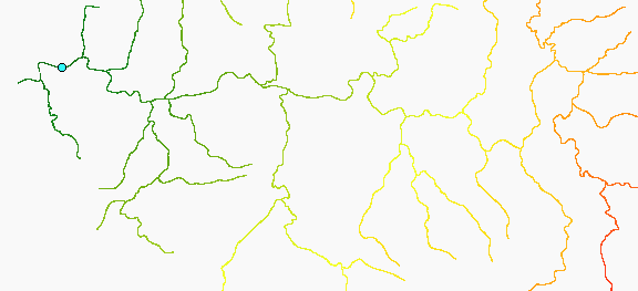
Using the Distance Accumulation tool with a surface raster, you can calculate the surface distance along a network from a set of locations on that network. This can be useful, for example, to calculate the distance along streams upstream from stream gauges or the distance along roads from bus stops. The stream gauges or bus stops are provided as the sources and an elevation surface is provided for the Input surface raster parameter. The network over which the distance is to be computed is provided for the Input cost raster parameter. The cost raster will have a value of 1 assigned to all cells on the network and NoData to all cells that are not on the network.
To obtain more accurate results, set a smaller cell size when you rasterize the network to create the cost surface. Then apply a thickening operator to the rasterized versions of the network features. Focal Statistics is a good way to thicken a raster representing a linear network. It widens the paths in the raster network while generally preserving the individual cell values on the network.
Calculate actual travel distance between cells
The tool applies the Pythagorean theorem to calculate the actual travel distance between two cells. The Pythagorean theorem calculates the actual surface distance as the hypotenuse of the distance between the cells and the difference in elevation.
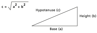
If the cost distance is being calculated to one of the four adjacent neighbors, the length of the base (a) is equal to the cell size (the distance from the center of one cell to the center of another). If the cost distance is being determined to a diagonal cell, the base is derived from the cell size times approximately 1.414214 (or, √2). To determine the height (b) of the triangle, the height of the first cell on the surface raster is subtracted from the height of the second cell.
This is a conceptual description of the calculations. For detailed information, see Distance accumulation algorithm.
Note:
On occasion, the linear x and y units of an input surface raster may differ from the vertical units. However, the units must be the same when performing the calculations. To ensure they are, the tool will make the necessary adjustments for the following situations:
- If the input surface raster is projected and has a vertical coordinate system (VCS), when the units differ, the tool converts the necessary units to make sure they are all the same.
- If the surface raster is projected and does not have a VCS, it is assumed that the surface units are the same as the horizontal units.
If the surface raster is in an unprojected (geographic) coordinate system, such as having units of decimal degrees, do not use the Planar distance method. You can use the Geodesic method on an unprojected raster. If there is an associated VCS, the units will be converted to meters if they are not already. If there is no VCS, it is assumed the vertical values are meters. All calculations in Geodesic are in meters.