Note:
Find by Attributes and Location is equivalent to Find Existing Locations and Derive New Locations in Map Viewer Classic.
The Find by Attributes and Location tool creates a new layer of the features or parts of features that meet specified spatial or attribute criteria.
The output is a hosted feature layer.
Learn more about how Find by Attributes and Location works
Examples
Example uses of this tool include the following:
- A real estate development company is looking for suitable areas to build a mixed-use development. The development will be in an area with plenty of young adults in their 20s and 30s with easy access to the city's light-rail system. Use the Find by Attributes and Location tool to create features within the city limits that are zoned for mixed-use development and fit the selection criteria.
- State park officials are concerned about interactions between cougars and humans and decide to map potential cougar habitat within the park. The habitat will be based on criteria such as vegetation, slope, and proximity to roads. Use the Find by Attributes and Location tool to create habitat areas that meet the suitability criteria.
Usage notes
The Find by Attributes and Location tool includes configurations for criteria and the result layer.
Criteria
The Criteria group includes the following parameters:
- Spatial and attribute queries defines the criteria used to find features. Those features, or portions of features, that satisfy all criteria will be written to the result layer. To define a query, click Build new query. You can only build queries using the layers on the map.
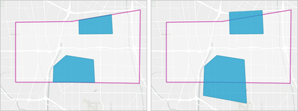
- Include only the parts of features that meet the criteria specifies how a feature is returned when only a portion of it meets the criteria.
- Checked—Only the portions of the feature that meet all criteria will be returned.
- Unchecked—The entire feature will be returned provided at least a portion of the feature meets all criteria. This is the default.
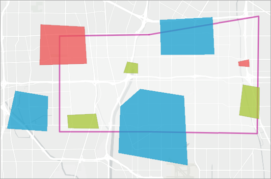
- A polygon layer colored in blue, red and green.
- A polygon layer that is transparent with a pink outline.

This example finds the polygons where the colour is blue and they intersect with the transparent polygons with the pink outline. The following two outputs show the difference in results when Include only the parts of features that meet the criteria is checked (first image) and unchecked (second image):

Result layer
The Result layer group includes the following parameters:
- Output name determines the name of the layer that is created and added to the map. The name must be unique. If a layer with the same name already exists in your organization, the tool will fail and you will be prompted to use a different name.
- Save in folder specifies the name of a folder in My content where the result will be saved.
Environments
Analysis environment settings are additional parameters that affect a tool's results. You can access the tool's analysis environment settings from the Environment settings parameter group.
This tool honors the following analysis environments:
- Output coordinate system
- Processing extent
Note:
The default processing extent in Map Viewer is Full extent. This default is different from Map Viewer Classic in which Use current map extent is enabled by default.
Outputs
The Find by Attributes and Location tool creates an output hosted feature layer with the same geometry types as the layer that was used to find results.
The output includes attributes from the input feature where features were found. There may be additional fields from features that were used in spatial operations. Some fields may be renamed if field names are duplicated.
Licensing requirements
This tool requires the following licensing and configurations:
- Creator or GIS Professional user type
- Publisher or Administrator role, or an equivalent custom role
ArcGIS Server Advanced is required to create a spatial expression using Does not intersect or Not within a distance when Include only the parts of features that meet the criteria is checked.
Resources
Use the following resources to learn more:
- Find Existing Locations in ArcGIS REST API
- Derive New Locations in ArcGIS REST API
- find_existing_locations in ArcGIS API for Python
- derive_new_locations in ArcGIS API for Python
- Select features by Location in ArcGIS Pro
- Select layer by Attribute in ArcGIS Pro