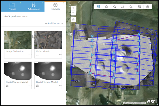
Ortho Maker is a web app in ArcGIS Enterprise for creating orthoimage mosaics and terrain surface products using imagery from drones. These mapping products are created using a guided workflow that leads you through the three steps of a project:
- Project setup
- Block adjustment
- Product generation
Ortho Maker is powered by Enterprise and ArcGIS Image Server. It uses the distributed processing and storage capability of Enterprise and ArcGIS Image Server to quickly process hundreds or thousands of images collected by drones and create seamless orthoimage mosaics, digital surface models (DSM), and digital terrain models (DTM). Additional value-added products include visible atmospheric resistant index (VARI) maps for analyzing the coverage and relative health of vegetation, and slope and aspect surface maps for suitability analysis or assessing the influence of topography on development and natural features. You have the option to create custom products, which are based on image band math operators, to create indices such as urban indexes, moisture indexes, and other types of image analysis.
Ortho Maker web app tasks are managed as a project, which manages and tracks orthoimage mosaic components defined in the project. The Project includes all project inputs, ancillary data such as image footprints and block adjustment reports, intermediate products such as image collections, quick block adjustment results, final products, and status at each stage of processing. New projects can be created, or an existing project template can be utilized and edited to meet the requirements of a particular job.
Ortho Maker advantages
Ortho Maker allows you to easily upload and process drone imagery. If you are new to drone processing, the default Ortho Maker settings make it easy to create accurate products with little knowledge of photogrammetric parameters. If you are an advanced drone user, Ortho Maker allows you to fine-tune your processing parameters to meet your needs. Ortho Maker offers many operational advantages for completing your drone image processing projects:
- Upload a collection of drone images and process them to create accurate orthoimages and digital elevation models.
- Easily create value-added VARI, slope, aspect, and hillshaded products.
- Powerful distributed processing and storage using your Enterprise ArcGIS Enterprise deployment.
- Guided workflows make project setup and production processing easy.
- Review your collection of drone images and remove unwanted images.
- Process your drone imagery with little experience in photogrammetry.
- Upload and manage ground control points to further improve the accuracy of processing results.
- Fine-tune processing parameters if you have experience processing drone images.
- Review and share detailed processing reports.
- Share your results for use with other ArcGIS software like Story Maps, ArcGIS Pro, and ArcGIS Image Server distributed analytics.
Create accurate orthoimage maps
An orthoimage map is built from a series of overhead images that have been corrected to remove sensor and topographic distortions in a process called orthorectification. Once the position of each image is corrected to a known accuracy, these images are mosaicked together. The resulting orthoimage map mosaic can be used as a basemap to collect and measure features and analyze and derive information using standard image processing techniques.
Orthorectification employs photogrammetric techniques using overlapping images, called stereo imagery, to derive a photogrammetric model and the required surface model used to correct systematic and topographic distortion in imagery. A block, or set, of overlapping imagery is adjusted using tie points in the areas of overlap, and ground control points across the project area. The tie points between overlapping stereo imagery are computed automatically, while the ground control points usually are provided from ground survey, or sometimes derived from existing orthoimagery. See Introduction to ortho mapping for more details about the orthorectification process.
Ortho Maker employs rigorous photogrammetric processes in a streamlined guided workflow for project setup and management, block adjustment, and the processing of ortho mapping products. This project management and sophisticated processing is executed behind the scenes on your ArcGIS Enterprise deployment using ArcGIS Image Server for distributed processing and storage, including deployment in the cloud depending on your configuration. The Ortho Maker project manager organizes all the inputs, verifies that they meet the minimum criteria for inclusion and use, facilitates the required block adjustment according to your criteria, and generates the products you specify in your project setup. An adjustment solution and accuracy report is generated for verification.

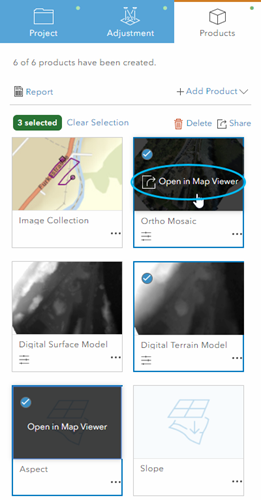
Products are automatically published as services to share with stakeholders across your organization. The products can be opened in the portal's Map Viewer Classic, where all of the tools and capabilities available in Map Viewer Classic can be used for further analysis.

Ortho Maker products can be used in ArcGIS Pro, the distributed analytics of ArcGIS Image Server, and ArcGIS Online. For example, you can build and test a compute-intensive hydrologic modeling processing chain and a segmentation and classification chain in ArcGIS Pro based on the DSM and color-infrared orthomosaic service produced in Ortho Maker, and then use your ArcGIS Image Server-distributed analytics deployment to distribute the processing across multiple instances in the cloud.
Ortho Maker is a valuable app in your ArcGIS ecosystem, and it takes advantage of the seamless integration between the different parts of ArcGIS. Advantages include scalable distributed processing and storage, an intuitive simplified workflow, and tight integration with other ArcGIS software, enabling interoperability to fully address your project requirements.
Three-step setup
The Ortho Maker guided workflow makes project setup and product processing straightforward and efficient in three steps.
Set up your project
The first step in the Ortho Maker workflow is to set up your project. In this step, you identify the folder containing your drone imagery and associated metadata files, which is then verified. Then you fill out the project setup form, where you assign a name and description for your project and choose a processing workflow.
The processing workflows generate a coverage map of your image collection to verify that you have proper coverage of your project area. You can optionally perform a quick adjustment to estimate that the accuracy of your final products will meet or exceed your project accuracy requirements. Then, perform a full block adjustment, verify final accuracy, and generate any or all possible products.
The project setup page is where you can define your settings for performing a quick or full adjustment and product generation parameters. The default settings are normally sufficient for generating high-quality products for most projects and applications. If you are an experienced user or have unique project requirements, you can define various settings for generating your Ortho Mosaic product, such as seamline generation between orthoimages, color balancing parameters, and defining an output pixel size (GSD) in meters. For surface products, you can define the point cloud matching methods for generating bare earth, detecting ground features in an urban area, maximum size for detecting buildings or trees as part of your surface, and defining ground spacing, and pixel size.
You can save your project settings to create a project template. Project templates can be imported, edited, and used for the current project or other projects.
Compute block adjustment
The Adjustment step includes two options, Run Quick or Run Full. The quick adjustment computes a block adjustment on the images at reduced resolution for preliminary QA purposes.
An initial block adjustment is computed to generate the tie points between overlapping images, and an adjustment report can be generated. Once an initial block adjustment has been computed, it can be refined by adding ground control points (GCPs). GCPs can be from a ground survey and imported from a file. If you have a feature service that contains GCPs (and GCP photos as attachments), you can import them from the feature service. GCPs can also be added from a map or existing orthoimage basemap with known accuracy.
If you choose to add GCPs from a basemap, a control point collection interface allows you to choose points on the basemap and the corresponding points on any number of images covering the point on the basemap. Any of the collected control points can be assigned as a GCP to be used in computing the block adjustment, or as a checkpoint to assess the accuracy of your orthoimage.
Once you have loaded and identified your GCPs on the images, the block adjustment is recomputed. The revised block adjustment runs quickly because the tie points derived from the initial adjustment are used for efficiency.
Generate products
The third step in the workflow is to generate photogrammetric products with Ortho Maker. These products include orthoimage mosaics and DSM and DTM surface products, complete with an accuracy assessment report. The processing parameters associated with each of these products can be edited or adjusted to meet your project requirements, and each product can be regenerated using the updated settings.
- Additional derivative products can be produced, including NDVI from orthoimagery, slope, aspect and hillshade maps, and service layers from the surface products.
- As part of the product generation process, products are automatically published to your ArcGIS Enterprise raster data store, where they can be shared with members of your organization according to their authorization and privileges.
- The products can be further analyzed and processed in Enterprise configured for raster analysis, ArcGIS Pro, and Map Viewer Classic clients.
Summary
Ortho Maker is a streamlined app for processing your drone imagery in a production environment. Ortho Maker guides you through project setup, block adjustment, and product generation to produce orthoimage mosaics and DSM and DTM products. Resulting products are automatically published and shared with members of your organization, and are suitable for further processing and analysis in ArcGIS Pro and ArcGIS Online.