Mobile workers sometimes work in areas without a reliable data connection, or with no data connection. For these situations, they can download maps that have been prepared for offline use. Once maps are downloaded, they can be used in the same way as when they're connected and receive updates upon request. Downloaded maps allow mobile workers to continue working with GIS data without a data connection.
There are four ways to take maps offline in Field Maps. The information presented in the Maps list helps determine how to take your map offline:
- If a map has offline areas, the Offline areas subheading appears under the map name (shown below). Tapping the map opens the list of map areas it contains. You can then download offline areas that have been defined.

- If a map card does not have the Offline areas subheading (shown below), the map does not contain offline areas. Tapping the map card will open the entire map if you're in a connected environment. To take the map offline, tap the Overflow menu
 to define and download offline areas.
- If the map card contains the Download icon
 (shown below), you must download the map to use it:
- Some maps may not appear for download in the app. Instead, you get them from a website, they are sent to you by email, or something similar. These shared files have the .mmpk file extension, and must be downloaded outside of the app and copied to your device.
When you're finished working with a downloaded map, remove it from the device.
Note:
Downloaded maps and offline map areas are used offline even if the device has a data connection. However, an online version of the map remains available to use after maps and map areas are downloaded.
For information about authoring maps for download, see Prepare maps for download.
Tip:
To ensure that your cellular data plan isn't used to download maps, go to your Profile  , tap Cellular data, and turn off Downloads. To prevent automatic updates from using cellular data, turn off Sync and update in the Cellular data setting as well.
Download defined map areas
If the map has offline map areas that have already been defined, download them by completing the following steps:
Note:
Map areas are used offline even if the device has a data connection. However, an online version of the map remains available to use after maps and map areas are downloaded.
- In the list of maps, tap the map you want to download.
- Tap a map area.
The map area begins downloading to the device.
- Once downloading completes, open the map area and work with it as you would any map in Field Maps. You can open and use it with or without a data connection.
Note:
When using a downloaded map area, you must use a basemap downloaded with the map, referenced from your organization, or copied to your device. Basemaps must overlap the extent of the map area and their spatial reference must match that of the default basemap. The basemap that's used is set in the offline basemap settings in the Field Maps Designer web app.
You can access the online version of the map by tapping the map card in the Online map section of the map areas list.
Tip:
If you don't see the map area you want to download, you can define and download an offline area using the Overflow menu  next to the online version of the map.
Define and download a map area
If the map is configured for offline use, you can define and download a map area by completing the following steps:
Note:
Map areas are used offline even if the device has a data connection. However, an online version of the map remains available to use after maps and map areas are downloaded. Additional map areas can be created with the mobile app even if some have already been defined.
- In the list of maps, find the map that you want to download and tap its Overflow menu
 .
.Tip:
If the map already contains offline areas, tap the map card and tap the Overflow menu
 next to the online version to add additional areas.
 - Tap Add offline area.
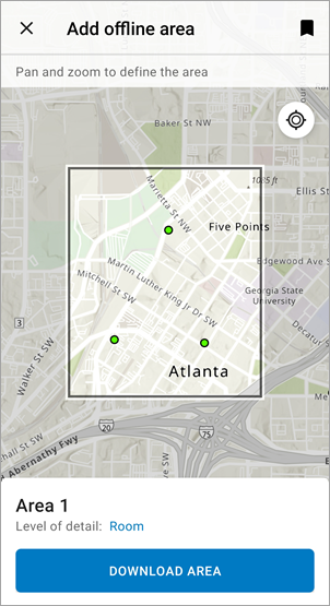
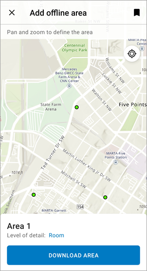
- Pan and zoom the map so the area you want to download is visible.
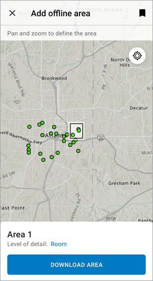
The initial extent is the default extent of the map. Due to limitations on the number of tiles that can be downloaded, you can't always download the entire extent. A gray mask covers the areas that won't be included in the download. If you don't see a mask, the area on the screen is downloaded.
Tip:
You can use a bookmark to bring an area of interest onto the screen. Tap Bookmarks
 and select the area you are interested in.
The unmasked area will be downloaded. 
The mask is outside the visible extent. The area on the screen will be downloaded. Tip:
The initial extent can be large and the mask may appear to cover the entire map, making it hard to see the unmasked area. To see the area that will be downloaded, zoom in until you can see the unmasked area.

- Optionally, tap the Level of detail value below the default area name to specify the amount of detail you need.
If the map uses a raster tile layer (as either a basemap or a reference layer), you see Level of detail below the default area name. The value next to Level of detail is an indicator of how far you'll be able to zoom in and clearly see a background on the map area once it is downloaded (beyond that, you can zoom in, but it will be pixelated). If the current level of detail doesn't meet your needs, tap the current level to display a list of available levels and choose one to specify the amount of detail you need. Map authors can define the range of levels available using Field Maps Designer.
By default, the downloaded map area uses the highest level of detail supported by the basemap. If you don't need that level of detail, consider choosing a coarser level. This makes the download faster and uses less space on your device.
If you need to download a larger area than is shown unmasked, change Level of detail to decrease how far you can zoom in without the background becoming pixelated, which increases the downloadable (unmasked) area.
If your map uses a vector tile basemap, you don't see the level of detail setting. All zoom levels are supported on vector tile basemaps.

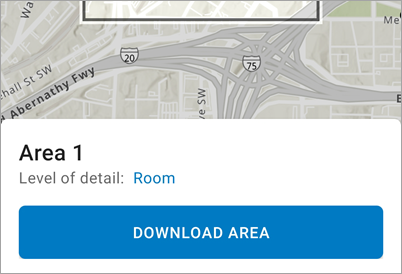
- Tap Download Area.
You are returned to the list of maps and can see the downloading map area in the On device section of the list.
- Once the download completes, you can tap Rename area in the map area's Overflow menu
 to rename it.
 - Open the map area and work with it as you would any map in Field Maps. You can open and use it with or without a data connection.
Note:
When using a downloaded map area, you must use a basemap downloaded with the map, referenced from your organization, or copied to your device. Basemaps must overlap the extent of the map area and their spatial reference must match that of the default basemap. The basemap that's used is set in the offline basemap settings in Field Maps Designer.
You can access the online version of the map by tapping the map card in the Online map section of the map areas list.
To define and download another map area, tap the Overflow menu
 next to the online version of the map.
Download a map
Some maps in Field Maps must be downloaded to use them. If your map has a Download icon  , tap the map to download it. Once downloaded, the map is designated as an On device map. Tap the map to open it.
Copy a map to the device
If you downloaded a map outside Field Maps (for example, from a website, or if it was sent to you in an email), copy it to your device to use it in Field Maps. Field Maps supports copying maps in .mmpk files.
- iPad and iPhone devices—Use iTunes and connect your device to your computer. See Apple Support for details on using iTunes to share files between your computer and your device, and follow the steps to copy the .mmpk file from your computer to the Field Maps app on your device.
- Android devices—Connect your device to your computer, use your computer's file explorer to browse to your device, and copy the .mmpk file to the \Android\data\com.esri.fieldmaps\files\mappackages folder.
Note:
If you're using Android 11, you may not be able to access the device's external storage when connecting it to a computer. For more information, see How To: Sideload mobile map packages (MMPKs) and basemaps to ArcGIS Field Maps using Android 11.
Once you copy it to your device, the map is listed in the On device section of the Maps list. Tap the map to open it.
Note:
If Field Maps was open when you copied the map, you must reopen it or refresh the list of available maps to see the copied map in the On device section.
Copy a basemap to the device (optional)
If a basemap was created to copy to your device, user your device's file system to add it. On Android devices, copy the file to the device or SD card. On iOS devices, use the Files app or iTunes. On iOS, you must restart Field Maps on your device to see the updates made to the basemap.
- On Android—Plug your device or SD card into your computer. Using a file explorer on your computer, browse to \Android\data\com.esri.fieldmaps\files\basemaps (if the folder doesn't exist, create it). Copy the basemap file (.tpk, .tpkx, or .vtpk) you want on your device to the basemaps folder.
Note:
If you're using Android 11, you may not be able to access the device's external storage when connecting it to a computer. For more information, see How To: Sideload mobile map packages (MMPKs) and basemaps to ArcGIS Field Maps using Android 11.
- Files app (iOS)—Copy the basemap file (.tpk, .tpkx, or .vtpk) you want on your device to a website that is available in the Files app, for example, iCloud Drive, Box, or Google Drive. In the Files app, browse to where you uploaded the basemap file and copy it to your device, placing it in the Field Maps folder. See Apple Support for complete steps on using the Files app on your device.
iTunes (iOS)—Connect your device to your computer and go to your device in iTunes. Browse to the files shared with the device and select the Field Maps app. Drag the tile package (.tpk, .tpkx, or .vtpk) to the documents section for Field Maps. See Apple Support for complete steps on using iTunes to share files between your computer and your device.
On Android, the basemap is immediately ready for use. On iOS, the next time you access basemaps, the tile package is moved to the Basemaps folder on your device and is available for use in Field Maps.
Open and use a downloaded map
Once you download a map to your device, you work with it in the same way as an online map. In the Maps list, tap the map to open it or select a map area to open. Then you can pan and zoom, capture data, perform inspections, use markup, and share location in the same way as any map.
Note:
If you are collecting data or performing inspections offline, you'll need to sync your work once you're back in a connected environment. The data you collect will not be reflected in the online version of the map until you sync. For more information, see Sync your work.
Limitation
The functionality available in downloaded maps in Field Maps has the following limitation:
- Place search
While you can search for your assets without a data connection, searching for place-names and addresses requires a data connection. If you have a data connection while using your downloaded map, you can search as you do in an online map.
Update a downloaded map
Maps change over time. More data may be added to it, or the map author may update the map. If changes are made to a map while you have it downloaded, you won't see those changes until a request (either manual or automatic) is made. Check for updates to get the latest content for downloaded maps. You can check for them whenever you regain connectivity to confirm you have the latest map.
How you get the updated map depends on the type of changes made and the way you downloaded the map you are using.
Note:
A data connection is required to get updates.
Update an offline area
Check offline areas for updates to downloaded changes to the data in the offline areas you use. Checking for updates requires a data connection. Field Maps automatically checks for updates every 15 minutes; you can also check for updates manually. Manual requests are made in the list of maps—find the map area you want to update and tap its Overflow menu  . If it's a read-only map, tap Check for Updates. If it's a map enabled for editing, tap Sync.
When you check for updates, the data in the map is updated at that time. This includes the addition of new assets and updates to existing assets. For example, you have a map with a layer of parks and their amenities. A new park was built in town, and the new park was added to the parks layer. You won't see the new park and its amenities in your downloaded map until you check for updates.
Some changes to the map (as opposed to the data in it) don't appear when you check for updates. The following are some types of changes that require you to re-create map areas and mobile workers to download them again. Unless specified otherwise for a particular change, making these changes doesn't affect the ability of mobile workers to sync their changes before removing map areas and downloading them again.
- Symbology changes—Provide a better symbol to your mobile workers, for example, if there is a new standard symbol that they expect to see.
- Add or remove layers—There may be a new reference or editable layer your mobile workers need access to, or a layer that is no longer needed.
- New search capabilities—Search another layer, update hint text, or change how an existing search on your data is done.
- Changes to pop-ups—Change what mobile workers see in the read-only pop-up configuration.
- Form updates—There are two kinds of updates you can make to the form: changes to the form configuration and changes to the schema of your data (which defines the entries you can configure in your form).
Form configuration is done in the map. You can update the read-only or editable form. For example, you can provide a new default value or enable editing on an entry.
Schema changes are done in your layer. There may be a new entry you want in the form (a new field in your data), or a new value you want included in a list of choices presented to the mobile worker (an update to a coded value domain). If using ArcGIS Pro, you must republish your layer after making your changes.
- Disable sync on a layer—For example, the layer should no longer be used offline, or you need to update existing assets or observations on the layer's details page.
Caution:
Before you disable sync, ensure that all mobile workers with the downloaded layer have synced their edits and removed all downloaded maps containing the layer from their devices. If you disable sync while mobile workers have the layer downloaded, they won't be able to sync their edits (even if you reenable sync for the layer).
Once you have disabled sync, open and save each map that contains the layer to ensure that the maps reflect the sync settings of the layers they contain. Then mobile workers can download the map again and see the updates.
- Change layer filters—Change how mobile workers can filter features on the map.
Update a downloaded map
If your map was downloaded in its entirety (not as areas), check for updates to download all changes. In the list of maps, find the one you want to update. If it's designated as Download available, tap its Overflow menu  and tap Check for download.
Update a copied map
If your map was downloaded outside Field Maps as an .mmpk file and copied to your device, you must manage updates manually. Remove the map from your device the same way you added it, get a new version of the file, and copy the updated file to your device the same way you originally copied it.
Remove a downloaded map
You may need to remove a downloaded map or map area because you're finished with it, updates have been made to the map (not just its data), it's taking up too much space on your device, you want to use it while connected, or you're finished using the device and you're handing it off to a coworker.
Tip:
If you're using a map that was downloaded in its entirety in Field Maps (not as areas) or if only the data in your map area has changed, update it instead of removing it and downloading it again.
In the list of maps, find the downloaded map or map area you want to remove. Tap its Overflow menu  and tap Remove for maps or Remove Area for map areas.