ArcGIS Knowledge allows you to create knowledge graphs backed by an ArcGIS Data Store graph store or a supported NoSQL data store.
Use ArcGIS Pro with ArcGIS Enterprise to create a knowledge graph, add and analyze data, and find or document relationships in the system. The following steps are required to create a knowledge graph:
- Configure ArcGIS Enterprise
- Set up and license an ArcGIS Knowledge site
- Assign user privileges on the ArcGIS Enterprise portal
- Set up ArcGIS Pro to create a knowledge graph
Configure ArcGIS Enterprise for ArcGIS Knowledge
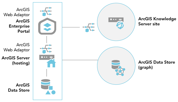
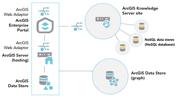
For members of your organization to create, edit, and use knowledge graphs in ArcGIS Enterprise, you must set up a base ArcGIS Enterprise deployment, if you do not already have one; ArcGIS Knowledge Server; and a graph ArcGIS Data Store. You can optionally add a supported NoSQL data store.
Components needed to use ArcGIS Knowledge
You need two ArcGIS Server sites. One site is for the portal's hosting server in the base ArcGIS Enterprise deployment. The other site will act as the ArcGIS Knowledge Server site.

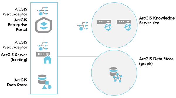
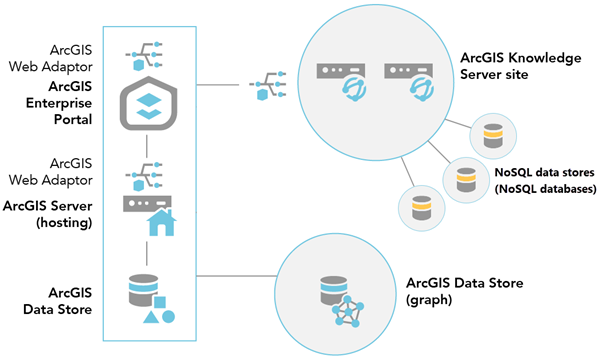
Depending on the size of your data, and the analysis you are completing, you may need to add additional machines to your ArcGIS Knowledge Server site to accelerate your analysis. The diagram below illustrates this deployment pattern. The following example includes a two-machine ArcGIS Knowledge Server site:

ArcGIS Enterprise deployment
You must have the following components in the ArcGIS Enterprise deployment before you can configure ArcGIS Knowledge:
- Portal for ArcGIS.
- An ArcGIS Server site licensed as the GIS server and set as your portal's hosting server.
- Two installations of ArcGIS Web Adaptor—one configured with the portal and one configured with the GIS server.
- At least two installations of ArcGIS Data Store—one configured as a relational data store and one configured as a graph store. You must deploy the graph store on a different machine than any of the other ArcGIS Enterprise components.
ArcGIS Knowledge Server site
This site requires the following components:
- An ArcGIS Server site licensed as ArcGIS Knowledge Server and configured using the steps below.
- An installation of ArcGIS Web Adaptor configured with the site licensed as ArcGIS Knowledge Server.
NoSQL data store
You can optionally add a NoSQL data store to the ArcGIS Knowledge Server site. A NoSQL data store connects the ArcGIS Knowledge Server site to a NoSQL database. Each NoSQL data store can be associated with one or more knowledge graphs depending on how the data in the NoSQL database is managed.

When you have configured a multimachine ArcGIS Knowledge Server site, you can add NoSQL data store items to the site.

Set up ArcGIS Knowledge Server
The following instructions may require changes to the way you deployed ArcGIS in your organization. Review them carefully before proceeding. To set up ArcGIS Knowledge Server, follow these steps:
- If you do not already have a base ArcGIS Enterprise deployment configured, set one up.
See Tutorial: Set up a base ArcGIS Enterprise deployment for more details.
- Install ArcGIS Data Store and create a graph store that you register with your base deployment's hosting server.
- Set up a second ArcGIS Server site by installing ArcGIS Server on one or more machines. License this ArcGIS Server site as the ArcGIS Knowledge Server.
- Install an additional instance of ArcGIS Web Adaptor and register it with the second ArcGIS Server site.
- Ensure all required ports are open in your system for intermachine communications.
See the following for specific ports needed for each component:
- Sign in to the portal as a member with administrative privileges.
The URL is in the format https://webadaptorhost.domain.com/<webadaptorname>/home.
- Browse to Organization > Settings > Servers.
- Federate your ArcGIS Knowledge Server site with your portal.
Note:
All ArcGIS Knowledge Server sites federated to an ArcGIS Enterprise 11.3 portal must have version 11.3 of ArcGIS Knowledge Server.
- On the Servers page, locate the ArcGIS Knowledge Server site that you federated with the portal.
- Click the options button next to the configured server and select Configure server role.
- On the Configure server role dialog box, enable ArcGIS Knowledge Server.
- Click Save.
Once a server role is configured, you can update it as needed by clicking the options button next to the configured server and selecting Configure server role on the Organization > Settings > Servers page.
- Optionally, add a NoSQL database to the ArcGIS Knowledge Server site as a NoSQL data store item.
You can complete this operation in the Enterprise portal now. You can also do this later in ArcGIS Pro after it is set up to create a knowledge graph.
Configure user privileges on the ArcGIS Enterprise portal
Members of your organization must be able to sign in to the ArcGIS Enterprise portal and have sufficient privileges for the tasks they need to complete with the knowledge graph. The organization administrator must grant members sufficient privileges to create, edit, or use knowledge graphs in ArcGIS Pro as described below.
- To allow members of the organization to create a knowledge graph, add them to the default Publisher role or add them to a custom role with the following general privileges (at minimum) as described below, depending on the type of knowledge graph that will be created.
- Hosted knowledge graphs that only use a graph store:
- Content—Create, update, and delete
- Content—Publish hosted knowledge graphs
- Knowledge graphs that use a NoSQL data store:
- Content—Create, update, and delete
- Content—Publish server-based layers
- Hosted knowledge graphs that only use a graph store:
- To allow members to edit a knowledge graph's content or load data into a knowledge graph, add them to the default Data Editor role or add them to a custom role with the Features: Edit general privilege (at minimum).
You must enable editing on the knowledge graph if members other than the knowledge graph owner or organization administrator need to edit it.
- To allow members to access a knowledge graph and view its content in an investigation, add it to a map, or create a link chart, add them to the default Viewer role or create a custom role that has the general group privilege and one or both of the following privileges:
- Groups: Join organizational groups—Add this privilege to the custom role to provide viewers with access to knowledge graphs and other content via groups.
- Content: View content shared with the organization—Add this privilege to the custom role to allow viewers to access knowledge graphs and other content shared with the organization.
Note:
All users must be signed in to the ArcGIS Enterprise portal organization where the knowledge graph exists to access the knowledge graph. You cannot share a knowledge graph to everyone, only to members of the organization.
Set up ArcGIS Pro to create a knowledge graph
Use ArcGIS Pro with ArcGIS Enterprise to create a knowledge graph, create entities and relationships to model and investigate a system, create link charts, and analyze the knowledge graph's spatial and nonspatial entities and relationships. Entities associated with spatial data can be visualized in a map in ArcGIS Pro.
- Install and start ArcGIS Pro.
- On the start page, click Settings
 .
. - Click the Portals tab.
- Add the ArcGIS Enterprise portal that was configured and federated with the ArcGIS Knowledge Server site to the list of portals that ArcGIS Pro can access.
- Make the portal with the ArcGIS Knowledge Server site your active portal.
- Sign in to the portal as a user who has sufficient privileges to create a knowledge graph.
- Optionally, add a NoSQL database to the ArcGIS Knowledge Server site as a NoSQL data store item.
- Create an investigation and a knowledge graph at once in an ArcGIS Pro project.
A knowledge graph service is created. The service is referenced by a knowledge graph item created in the ArcGIS Enterprise portal.
Use the investigation in the ArcGIS Pro project to access the knowledge graph service and create entities and relationships if the knowledge graph is editable.
Share the knowledge graph item with other organization members in the ArcGIS Enterprise portal. Members can add the existing knowledge graph item to their project to create an investigation that references the same knowledge graph service. Depending on their privileges in the ArcGIS Enterprise portal and how the knowledge graph service is configured, they can edit the contents of the knowledge graph service or analyze and present the content in maps and link charts.
Restrictions for naming knowledge graphs and their content
Different components of a knowledge graph have different naming restrictions. Because you create an investigation, a knowledge graph, and underlying knowledge graph service at the same time in ArcGIS Pro, restrictions are in place that limit the name you provide to one that satisfies the limitations of the knowledge graph service. You can later rename the investigation in the project and the knowledge graph in the portal following the naming rules associated with project and portal items.
The restrictions for different components are described below.
Knowledge graph service—Unicode characters can be used with some restrictions when creating a knowledge graph:
- The service name cannot start with a number, a period (.), an underscore (_), or the text esri__. Also, leading and trailing spaces are not permitted. These characters can be used between other characters in the name.
- Some characters are not permitted anywhere in the service name, including the forward slash (/), the colon (:), and control characters such as \n and \r that correspond with ASCII codes less than 32.
- The name must have a maximum of 111 bytes.
NoSQL database—Any Neo4j or ArangoDB database that is registered as a NoSQL data store must have a name or alias that meets the same criteria as the knowledge graph service.
Entity types, relationship types, and properties of entities and relationships—When defining a property for an entity type or a relationship type, these names are subject to similar restrictions as knowledge graph services.
- The property name cannot start with a number or the text esri__.
- Some characters are not permitted anywhere in the property name, including spaces and ASCII symbols such as the forward slash (/), the colon (:), and control characters such as \n and \r that correspond with ASCII codes less than 32.
- The name must have a maximum of 64 Unicode characters.
- The name must not be a reserved keyword in any associated system such as objectid, globalid, NONE, RETURN, CONTAINS, and so on.